When we look at a mountain face, a camera captures the rock layers directly. The layers, folds and cliffs are visible. The subsurface offers no such view, because we can’t photograph what lies kilometres below our feet.
Seismic surveys solve this by sending sound waves into the Earth and recording the echoes that return from rock boundaries. The raw recording is not a picture. It is a noisy collection of signals, mixed with multiples, surface waves, distorted amplitudes and wave energy that has travelled to the wrong place.
Seismic data processing turns those recordings into an interpretable image. Typical steps include noise attenuation, deconvolution, velocity analysis, stacking and migration, which moves reflections to their true positions.
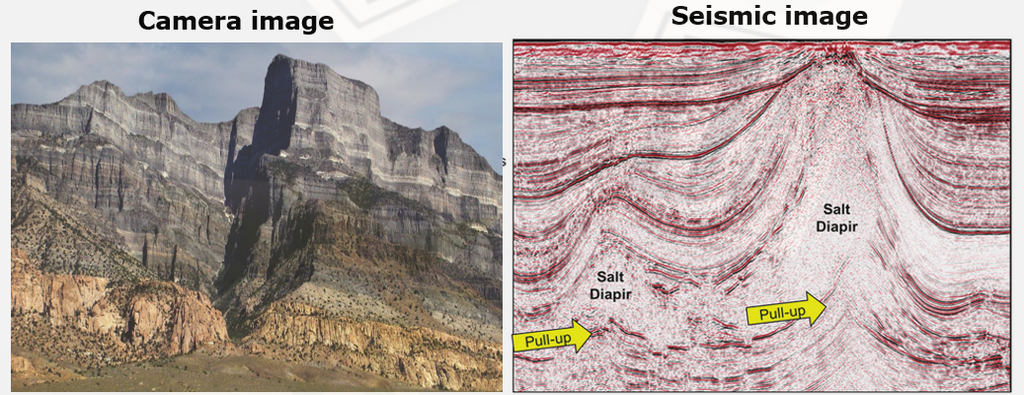
What the figure shows
- Left (camera image): an outcrop where the rock layers are directly visible.
- Right (seismic image): a processed cross-section of the subsurface. The red and black bands are reflections from rock layers, and the scale bar is 1 mile.
- Pull-up (yellow arrows): seismic waves travel faster through salt than through the surrounding sediments. Reflections beneath the salt therefore arrive early and appear shallower than they really are. This is an imaging artefact, not a real structure, and interpreters must recognise it to avoid mapping false highs.
Takeaway: processing does not just clean up the image. It decides whether we can trust what we see, and good interpretation depends on understanding both the geology and the artefacts of the method.